An update on next week's storm...
It still looks like we'll be dealing with a significant precipitation event for the middle of next week. While yesterday's model runs were trying to figure out a way to make this a coastal system with cold air involved, I pointed out that climatology was not favorable for a substanial winter event, at least in central and eastern Virginia. Today's model runs look more reasonable, with more energy hanging back to the southwest. Here's a look at the European model, which shows waves of moisture moving through the Mid-Atlantic. This would mean periods of rain Tuesday, Wednesday and possibly Thursday. The forecast map is effective Wednesday morning at 7 A.M.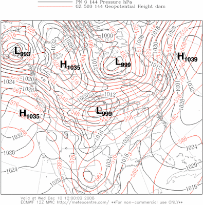

Taking a look at the GFS run, there is more of a trend toward the coast, but clearly the upper pattern holds the trough back to the west and it doesn't go negative (leaning back to the northwest) until the storm virtually passes, meaning it just won't get that cold until after the precipitation is gone. So there have been a few big changes today, showing that it's likely we just deal with rain next week...but we've still got plenty of time to watch for future changes. Stay tuned...


No comments:
Post a Comment