Saturday, August 29, 2009

Danny Heading Out to Sea...A "Cooler" Change on the Way...


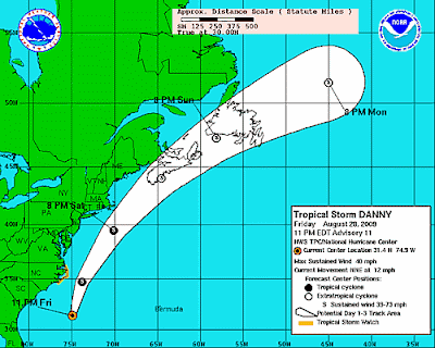
Tropical Storm Danny continues to be rather weak and has increased its forward speed as it now heads north-northeast well off the East Coast. The storm is expected to pass by the Outer Banks of North Carolina early Saturday morning and then offshore of southern New England Saturday evening. It should move near the Canadian Maritimes on Sunday.

As for effects on the Mid-Atlantic coast, there won't be much in the way of rain or wind at all. The main problem will be a high risk of rip currents due to large ocean swells. Dangerous surf condiitions will continue into Saturday night.

In central Virginia, an upper low crossing the region has brought showers, but those will taper Saturday morning. Somewhat drier air will mean the sun will pop out, although with rather high moisture content in the atmosphere we could still see an isolated shower or thunderstorm around during the day. Then on Sunday, a cold front will approach from the west offering the possibilty of a few scattered afternoon thunderstorms. Behind this front, a signficant change is on the way, with afternoon temperatures in the 70s early next week. The front will actually linger over the southern Mid-Atlantic and Southeast. At this time, it appears a few ways of low pressure may move along the front, potentially bringing occasional rain chances, particularly late Monday into early Tuesday and then again Tuesday night into early Wednesday.

Friday, August 28, 2009

Friday Afternoon Update on Danny

As of midday, Tropical Storm Danny remains rather disorganized, now located 350 miles south of Cape Hatteras, NC. While the storm has wobbled a bit west, it is expected to resume its northwest track and turn to the north-northeast tonight. Danny will make its closest approach to the Outer Banks late tonight and early Saturday morning. A Tropical Storm Watch remains in effect from Cape Lookout to Duck, including the Pamlico and Albemarle Sounds. Maximum sustained winds are at 40 mph, making Danny a minimal tropical storm. While some strengthening is possible, that window of opportunity will be closing by tomorrow morning as the storm accelerates to the northeast. Large swells are expected to produce dangerous surf conditions and life-threatening rip currents along the East Coast through Saturday.

Danny will pass too far east of the Virginia coast to have any real impact in central Virginia. The official forecast track from the National Hurricane Center is below, followed by the latest computer model tracks from the most recent runs.

Early Friday Morning Update on Danny...

Tropical Storm Danny continues to inch its way closer to the U.S., but it's still expected to gradually curve north and northeast, staying well east of the Virginia coast. It's closest point of approach will be the Outer Banks of North Carolina and a Tropical Storm Watch is posted from Cape Lookout north to Duck. This means there is the possibility of tropical storm force winds along the North Carolina coast within the next 36 hours.

After strengthening earlier Thursday, Danny weakened a bit as of the late night advisory. Maximum sustained winds are at 45 mph. While some strengthening is possible, the overall computer model suite isn't as impressive as earlier runs, which showed the potential for a hurricane. The storm is quite disorganized and it's hard to pick out the center on satellite imagery.

If you have plans to go to the beach, be aware that even at Virginia Beach and up the Mid-Atlantic and New England coasts, large swells are expected to produce dangerous surf conditions and life-threatening rip currents through Saturday.

Central Virginia should not experience any significant impact from the storm. The overall wind flow should enhance the moisture content over the area Friday afternoon and evening, leading to numerous showers and a few thunderstorms. However, as the storm passes by on Saturday, drier air will gradually take over and we'll see a decent amount of sunshine. That doesn't mean rain chances will disappear though, as a cold front will approach from the west on Sunday. As this front sinks south and east of the region, somewhat cooler air will take over early next week.
The official NHC forecast track is shown below, followed by the late night computer model tracks.

Thursday, August 27, 2009

Danny...Thursday Midday Update

As of midday, Tropical Storm Danny is now located 550 miles south-southeast of Cape Hatteras, NC. It has moved somewhat erratically to the northwest, but is still expected to turn to the north by tomorrow and then increase its forward speed. A look at the computer model data from the morning runs (below) shows that the suite is in very good agreement, keeping the center of the storm well offshore. The official NHC forecast follows this lead and if this track verifies, central Virginia will experience minimal impact from Danny. The main effect will likely be the onshore flow ahead of the storm, which will increase the available moisture for scattered showers and thunderstorms along a nearly stationary front over the region. The greatest threat will come later tomorrow and tomorrow night. By Saturday, subsidence (sinking air) on the back side of the storm will likely lead to sunshine, although a few isolated showers or thundershowers can't be ruled out.

Wednesday, August 26, 2009

Tropical Storm Danny and the Next Few Days...

As of late Wednesday night, Tropical Storm Danny was located about 675 south-southeast of Cape Hatteras, North Carolina. The storm is packing maximum sustained winds of 50 mph. It is moving northwest at 10 mph and this motion is expected to continue over the next 24 hours (through Thursday evening). The potential exists for further strengthening, and it is possible that Danny becomes a hurricane. The computer data is in good agreement that by late Thursday night and early Friday morning, Danny will turn north and then move parallel to the Eastern seaboard, well off the coast.

Even though the storm's center is expected to remain well away from the coastline, some impacts will likely be felt. Large swells, gusty winds and potentially heavy rainfall could skirt coastal areas later Friday night into Saturday. Inland, over central Virginia including the Richmond area, the effects may not be as significant. The exact track will determine what happens here, as any deviation in the track to the left could mean decent rainfall spreading inland.

As of now, central Virginia will likely be dealing with a few scattered showers and thunderstorms Friday afternoon and evening. This will be the result of a lingering front over the area and an enhanced onshore flow due to Danny. If the current forecast track verifies, the storm will accelerate as it moves up the coast and we could actually see some drier air moving in by Saturday afternoon as the flow shifts away from onshore. Either way, another front will slide into the region by Sunday morning, so at least some rain chances will linger through the weekend. Drier and somewhat "cooler" air will move into the Mid-Atlantic early next week.

National Hurricane Center official forecast:


Computer model forecasts for Danny (most recent runs as of late Wednesday evening):

Tropical Storm Danny...

The tropical wave we've talked about recently has become Tropical Storm Danny. It is located a little over 700 miles east-southeast of Cape Hatteras, NC as of late morning. The storm is expected to move west-northwest and then curve to the north and eventually northeast. Most of the computer models show the turn keeping the storm out to sea. However, a couple of models, including the shorter-range NAM and European show the storm potentially making landfall on the East Coast and moving up along the coast. If we feel any significant impacts from Danny, it would likely be later Friday and particularly Saturday. Stay tuned for updates!

Tuesday, August 25, 2009

Still Watching Tropical Development...Which Could Be Danny...

We're going to have more heat to deal with the next two days, as afternoon temperatures likely rise above 90 degrees. Rain chances will be minimal, although I wouldn't rule out a shower or thunderstorm Thursday afternoon.

The main attention continues to be focused on a tropical wave located about 350 miles north of Puerto Rico as of late Tuesday evening. Hurricane hunters did not find a closed circulation today, but upper level conditions are expected to become more conducive for development and most of our tropical models are forecasting at least a tropical storm to form over the next 24 hours. The latest model tracks shown below (from the late evening data) favor a track east of the coast by Saturday. However, the data has fluctuated a bit and we could see some interaction with a front over the region later in the week. Either way, it looks like we could see a decent influx of moisture over the area, which could lead to some decent rainfall to start the weekend. We'll have to keep a close eye on the development of this system...so stay tuned for updates!

Monday, August 24, 2009

Heating Up Again...and Keeping a Close Eye on the Tropics...

We enjoyed a rather pleasant day across central Virginia to start the new work week, with lots of sunshine and afternoon temperatures in the mid 80s. The temperature will start to climb, however, over the next 24 to 48 hours and the heat will be back in the Mid-Atlantic for a couple of days.

High pressure will move over us and then shift off the coast later Wednesday into Thursday, enabling temperatures to jump back into the 90s. Then the next front will slowly approach from the west and increase our rain chances later Thursday and especially Friday.

The start of the weekend could be rather interesting, as the tropics could get involved. As of late Monday night, a tropical wave is interacting with an upper low about 300 miles from the Leeward Islands. Conditions may become favorable for development with this system as it moves to the west-northwest. Some of our computer model data suggests this feature could have an impact over the Mid-Atlantic later Friday and Saturday, at the very least increasing the amount of moisture over the region. This is certainly something to keep a close eye on over the next few days, especially if you have weekend plans that take you to the coast.

Saturday, August 22, 2009

Severe Thunderstorm Watch Until 7 P.M.


A Severe Thunderstorm Watch is in effect for central and eastern Virginia until 7 P.M. Some storms may contain damaging winds and hail.

Mike's Weekend Getaway--August 22-23

THE BEACHES

** High Surf Advisory in effect from 6 A.M. Saturday until Noon Sunday **

Saturday: A mix of clouds and sun with scattered showers and thunderstorms...high in the mid to upper 80s
Sunday: Partly sunny, still a shower or two possible...high in the mid 80s

Water temperatures (as of Friday evening):

Virginia Beach: 81
Lewisetta, VA: 86
Ocean City, MD: 80
Duck, NC: 63
Wilmington, NC: 88

THE MOUNTAINS:

Saturday: Lots of clouds with a few scattered showers and thunderstorms...high near 80
Sunday: Partly sunny...high near 80

Friday, August 21, 2009

Severe Thunderstorm Watch Until 9 P.M.


A Severe Thunderstorm Watch is in effect for all of central Virginia until 9 P.M. Strong storms developing over the area may contain damaging winds and hail.


CLICK HERE FOR CURRENT WARNINGS

Friday, August 14, 2009

Mike's Weekend Getaway--August 15-16

THE BEACHES

Saturday: Partly sunny with a few scattered showers and thunderstorms around, particularly in the afternoon...high in the mid 80s
Sunday: Partly to mostly sunny...high in the upper 80s

Water temperatures (as of Friday evening):

Virginia Beach: 80
Lewisetta, VA: 84
Ocean City, MD: 81
Duck, NC: 76
Wilmington, NC: 87

THE MOUNTAINS

Saturday: Mostly sunny...high in the low to mid 80s
Sunday: Partly to mostly sunny...high in the low to mid 80s

Wednesday, August 12, 2009

Severe Thunderstorm Watch Until 9 P.M.


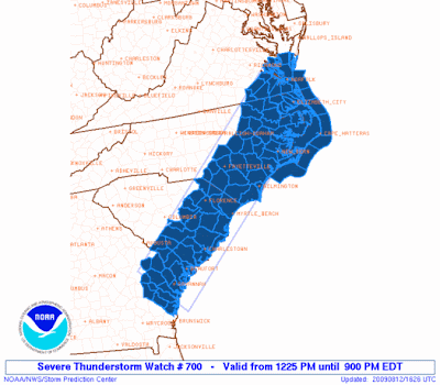
A Severe Thunderstorm Watch is in effect for southeastern Virginia until 9:00 P.M. Strong thunderstorms developing from Emporia to Hampton Roads may contain damaging winds and hail.

CLICK HERE FOR CURRENT WARNINGS

Tuesday, August 11, 2009

Severe Thunderstorm Watch across southern Virginia Until 10 P.M.


A Severe Thunderstorm Watch is in effect for many counties along the North Carolina border until 10 P.M. Strong thunderstorms developing across the area could produce damaging winds and hail.

Monday, August 10, 2009

The Perseids Are Here!

Courtesy: NASA
The annual Perseid meteor shower is now in full swing, and will peak this Wednesday morning, August 12th. The Perseid meteors usually put on one of the better shows of the year, the result of debris from the Comet Swift-Tuttle. The meteors are named after the constellation Perseus, which is where the shower appears to originate from. The shower is visible for several weeks (from late July into late August) in the summer sky, but the peak usually occurs on August 12th, when up to 60 meteors per hour may be seen this year. Under good viewing conditions, the meteors are very bright, but are actually very small particles of debris racing through space. The high rate of speed helps their visibility.

Tips on viewing this week's Perseids:

-- The best time to watch will be later Tuesday evening into the early morning hours of Wednesday
-- Get away from city lights and any source of light pollution (the less visible light, the better)
-- Look to the northeast toward the constellation Perseus (the meteor's tails will point this direction)
-- Allow your eyes to adjust to the dark sky...this could take a while, but it's worth it
-- Try to avoid light from the moon (the moon will be rising just before 10 P.M. Tuesday in the north sky)

While the Perseids appear to originate from the constellation Perseus, they can appear in any part of the sky. Usually the best time to view them is between midnight and dawn. However, the moon may get in the way this year. It will be low in the sky before midnight, so a good time to look may be between 10 P.M. and midnight. After that, the glow from the moon may temper the show a bit, although if you're in a real dark area, you'll probably get to see your share! Another concern is the weather and cloud cover, so check in with my latest forecast at richmondforecast.com!

Sunday, August 9, 2009

A Monday Scorcher!

The big time heat is here! As expected, temperatures this afternoon have reached the mid 90s and tomorrow will be the real scorcher. A developing west wind coming down the mountains will help to boost afternoon readings near the century mark on Monday. The record high at Richmond International Airport is 100 degrees, set way back in 1900. We certainly have a shot at that, as we expect plenty of sunshine to heat us up. There is the slight risk of an isolated afternoon thundershower, as a lee side trough sets up over central Virginia. Our rain chances will increase a bit on Tuesday as a front approaches from the west. This front will linger over or near the region for the rest of the work week, leading to a threat for scattered showers and thunderstorms each afternoon.

Saturday, August 8, 2009

Major League Heat Returns...

We've enjoyed a couple of pleasant summer days with afternoon temperatures in the 80s, but that's going to change. The big time heat is about to return, as high pressure settles along the East Coast. A building ridge in the upper atmosphere will set the stage for temperatures well into the 90s, flirting with the century mark and potentially giving us a new record high on Monday.

Tomorrow will be a sunny one, with afternoon highs in the mid and upper 90s. The heat index, which considers the combination of temperature and humidity, should reach up to around 101 degrees. Monday will likely be the hottest day, with the best shot at reaching a record high at RIC Airport. A west wind coming down the mountains should enable temperatures to soar up near the 100-degree mark during the afternoon (with a heat index around 106-107 degrees). A typical developing lee-side trough could spark an isolated afternoon thunderstorm, but the chances are very low.

We'll remain in a general westerly flow on Tuesday, but a slowly approaching front will bring a slightly higher threat for scattered afternoon thunderstorms. Temperatures will still reach the mid and upper 90s, but the extreme heat should eventually let up a bit on Wednesday. As the upper ridge flattens and the front settles over the region, we'll see our scattered shower and thunderstorm chances increase Wednesday through Friday.

Here are the record highs at RIC Airport the next few days:
Sunday: 101 degrees, set in 1930
Monday: 100 degrees, set in 1900
Tuesday: 102 degrees, set in 1900

Be sure to drink plenty of water to keep yourself hydrated and avoid long periods outside in the hot sun. Bring all pets inside and keep an eye on the elderly.

Thursday, August 6, 2009

Mike's Weekend Getaway--August 8-9

THE BEACHES

Saturday: Partly sunny...high in the upper 80s
Sunday: Partly to mostly sunny and very hot...high in the mid 90s

Water temperatures (as of Friday afternoon):

Virginia Beach: 80
Lewisetta, VA: 830
Ocean City, MD: 79
Duck, NC: 75
Wilmington, NC: 87

THE MOUNTAINS

Saturday: Partly sunny...high in the mid 80s
Sunday: Hot with a mix of sun and clouds...high in the upper 80s to low 90s