Wednesday, February 10, 2010

Snow this morning...

Low pressure developing along the Mid-Atlantic coast early this morning will deepen and move slowly northeast today. Temperatures will be on the way down, and wet roads will turn icy. Snow is likely during the morning, mostly on the lighter side in Metro Richmond, but heavier to the north. Accumulations of 1-2 inches are likely for the metro, but to the north in places like northern Hanover and Caroline, 2-4 inches are possible. A couple of hours of heavier snow are likely up near Fredericksburg over to the Northern Neck, where more significant accumulations will occur. The wind will become the main issue over the region as the storm strengthens, with sustained winds in the Richmond area of 20-30 mph, with gusts over 40 mph. Along the coast of the Northern Neck, the sustained winds could occasionally reach to around 40 mph, with gusts over 50 mph. With heavier snows occurring to the north, considerable blowing and drifting snow will reduce visibilities to near a quarter of a mile at times, and we could be talking about near blizzard-like conditions in the DC and Baltimore metro areas, as well as along the Maryland coast.

The snow will taper off across much of central Virginia around midday or very early afternoon, and the sun will actually make an appearance. However, the high winds will continue to be a problem into the evening. A Wind Advisory is in effect until 9 P.M.

Stay safe!

Tuesday, February 9, 2010

Yet another winter storm!

Here we go again! Low pressure will track into the Ohio Valley today, eventually giving way to a new storm that will develop along the Mid-Atlantic coast. While surface temperatures will hold in the low to mid 30s across the region, the track of the initial low will allow somewhat "milder" air to move in aloft. This will cause a mix of precipitation types, with Metro Richmond and areas south and east changing to some rain, while north and west locations stay snow and sleet. Accumulations through this evening will range from slushy/icy spots in the metro to a couple of inches of snow/sleet well north and west of Richmond. As the secondary low takes shape early Wednesday morning, colder air will change any mixed precipitation to snow. This will be a similar situation to what we experienced this past Saturday morning. There could be a few hours of heavy snow early tomorrow, particularly north of Richmond, extending to parts of the Northern Neck. By the time it tapers off by midday or early afternoon, we could see some impressive totals across northern Virginia once again, while the Metro Richmond area will likely see a general snowfall of 1-2 inches, with a few localities seeing as much as 3 or 4 inches just north of the city.

Saturday, February 6, 2010

Very early morning update...

The sloppy mess will be changing back to snow this morning in Metro Richmond and all the way to southeastern Virginia this afternoon. Additional significant accumulations are likely. Wet roads will quickly become icy as north winds lower the temperature, and snow will accumulate on top of the slippery surface. The winds will really kick up, causing blowing and drifting snow. Travel will be very hazardous, so don't go out if you don't have to!

Here's what I expect for snow totals today, for the last part of our latest winter storm:

Metro Richmond southwest to Farmville
3-5 inches

Western Goochland/Hanover
4-6 inches

Central/eastern Northern Neck
4-8 inches

Fredericksburg and upper Northern Neck southwest to Louisa
8-12 inches

Charlottesville/Culpeper/DC
12 inches +

Tri-Cities to Williamsburg
1-3 inches

Extreme southeastern Virginia/Hampton Roads/Emporia
1-2 inches possible later on

Friday, February 5, 2010

Evening update...

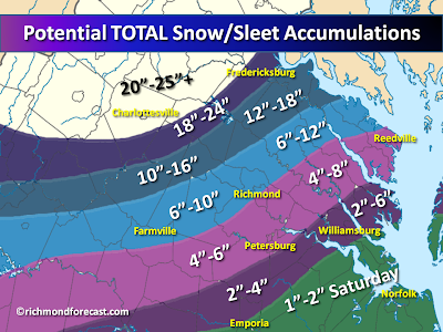
As of early evening, the rain/snow line has inched north of Richmond as expected. There are no real changes to the forecast. The map above shows the accumulation possibilities for what fell today combined with what I expect for tomorrow...so TOTAL accumulation through tomorrow night.

Here's the rundown for overnight and tomorrow by location:

Metro Richmond (city and east) down to southern Chesterfield and east to Urbanna
-- mainly rain during the evening, mixed with sleet overnight and then changing back to snow by sunrise
-- 3 to 5 inches of snow accumulation tomorrow

North and west of Richmond (from Short Pump/Hanover to the Northern Neck/south to Farmville:
-- rain and sleet this evening, mixing with and changing to snow after 3 A.M.
-- 3 to 5 inches of snow tomorrow (4 to 6 inches on the Northern Neck)

Farther north and west (from western Goochland/NW Hanover to the upper Northern Neck)
-- sleet/snow mixed with rain this evening and overnight, changing to back to snow during the wee hours of the morning
-- 3 to 5 inches of snow tomorrow (4 to 8 inches on the Northern Neck and Caroline County)

Fredericksburg southwest to Louisa
-- snow mixing with sleet into the wee hours of the morning, then all snow again before sunrise
-- 8 to 12 inches by 2 or 3 A.M. and another 8 to 12 inches tomorrow, making a total of 16 to 24 inches

Charlottesville up to northwest Virginia/DC/Baltimore
-- mostly snow (some sleet may mix in)...storm totals of 20 to 25 inches +

Well south and east of Richmond (Tri-Cities to Williamsburg)
-- rain tonight, changing to snow in the morning
-- 1 to 3 inches of snow tomorrow (2 to 4 inches from Williamsburg and the Middle Peninsula

Extreme southeastern Virginia/Hampton Roads (and Emporia)


-- heavy rain tonight and tomorrow morning (1 to 3 inches)
-- a change to snow in the afternoon with 1 to 2 inches possible through tomorrow evening
--

Friday afternoon update: What to expect and TOTAL snow/sleet accumulations through Saturday night

The winter storm is now underway and snow/sleet will continue over much of the region into the early evening. This will be a multi-part storm for the Metro Richmond area and much of the surrounding region. That's because we'll have the accumulating snow and sleet, followed by a change to rain tonight and then back to snow early tomorrow morning, with more significant accumulation possible. So while my earlier map showed potential accumulation for the metro before the changeover, I thought I'd post this one to show the potential TOTALS of snow and sleet for the entire storm. Keep in mind that rain in many places tonight will pack down or even wash away some of the afternoon snow, so the totals will be skewed. This map represents the potential accumulations for today and tomorrow added together. Locations well north and west of Richmond, from Charlottesville to northern Virginia/DC/Baltimore will stay mostly snow with some sleet mixed in, and they will likely need a yardstick to measure 2 feet or more of snow!

Here's the lowdown for what to expect in your neighborhood:

Metro Richmond (city and east) down to southern Chesterfield and east to Urbanna
-- 2 to 4 inches of snow this afternoon
-- changing to rain this evening (some heavy rain possible overnight)
-- back to snow by morning, with 3-5 inches possible tomorrow

North and west of Richmond (from Short Pump/Hanover to the Northern Neck/south to Farmville)
-- 4 to 8 inches of snow possible through this evening
-- mix with and possible brief change to rain tonight
-- back to snow by morning, with 3-5 inches possible tomorrow

Farther north and west (from western Goochland/Hanover up to the upper Northern Neck
-- 8 to 12 inches of snow possible through later tonight
-- sleet and even some rain may mix in tonight, back to snow tomorrow morning
-- 3 to 6 inches of snow possible tomorrow (highest on the Northern Neck)

Fredericksburg southwest to Louisa and Buckingham
-- 8 to 12 inches of snow possible through later tonight
-- mainly snow and sleet overnight, all snow tomorrow
-- an additional 8-12 inches possible through tomorrow

Charlottesville up to northwest VA/DC/Baltimore
-- mostly snow (some sleet may mix in)...20-25 inches + likely

Well south and east of Richmond (Tri-Cities to Williamsburg)
-- 1-2 inches of snow/sleet possible
-- changing to rain this afternoon, some heavy rain possible tonight
-- 1-3 inches of snow possible tomorrow (2-4 inches for Williamsburg/Middle Peninsula)

Extreme southeastern Virginia/Hampton Roads (and Emporia)
-- 1-3 inches of rain
-- changing to snow tomorrow
-- 1-2 inches of snow possible tomorrow afternoon/evening

Early morning update...

The current forecast is on track for now. It will be interesting to see where the rain/snow transition sets up this afternoon and evening, as that will have a huge impact on accumulation amounts across the metro. While we'll likely see rain tonight from the metro south and east, it should go back to snow by tomorrow morning. The model data shows significant precipitation over us tomorrow, which will be snow...so more significant accumulations are possible. Tomorrow could end up being worse than today for many locations, including the metro. The accumulation map below is for today through this evening for places that will mix and changeover...total storm accumulations for the far northwest. I'll further discuss potential accumulations for tomorrow in a later post. Let's get through today first! Stay tuned!

Thursday, February 4, 2010

Winter storm update...potential snowfall accumulations!


The much anticipated latest winter storm will be moving out of the western Gulf tonight, tracking to the northeast and redeveloping off the Mid-Atlantic coast. As I've mentioned previously, this will not be the same setup as last week's storm, which had Arctic air pouring into the region. This time, milder air will surge in from the south, especially aloft, which will cause a mix of precipitation types for Metro Richmond and locations south and east. The big snowfall winners will be to the north and west, from Charlottesville to DC and Baltimore, where 1-2 feet with locally higher amounts are possible. That's not to say we won't see anything significant here in Richmond. However, we will be right on the dividing line (so what else is new).
Here's the timeline:
Snow and sleet should develop across the region early tomorrow morning. In locations south and east of Richmond, we should see a very quick change to rain. In the city, I expect to see a change to rain during the afternoon, but a couple of inches may accumulate before that happens. Just to the west and north of town, from extreme western Henrico County through eastern Goochland and northeast to Ashland/King William and then over to the Northern Neck, more substanial snow and sleet is likely before a change to rain or even freezing rain a bit later (towards evening). Accumulation amounts will increase rapidly the farther north and west you are. For instance, I see about 8-12 inches of snow and sleet in western Goochland up through southern Caroline and the central/western Northern Neck. With such a strong surge of milder air, I expect even these areas will see a bit of a mix Friday night. However, from Charlottesville to Fredericksburg up to DC, this will likely be mainly a snow event (with some sleet mixed in, especially in Fredericksburg), and they'll likely be measuring the snow with yardstick. 1-2 feet is possible in this region up through central and western Maryland, with some locally higher amounts.
On the other side of the coin, southeastern Virginia will see heavy rain, with 1-3 inches expected and a Flood Watch in place.
Despite a change to rain from the city south and east tomorrow afternoon and evening, as the storm deepens off the coast on Saturday, colder air will take over the area again. This means we'll see a change back to snow for everyone, including coastal areas by afternoon. A couple more inches of accumulation are possible on Saturday, so be prepared! Accumulation amounts are a tough forecast where there will be mixed precipitation, but one thing is for sure, this storm will be a real mess!
Stay tuned for updates...

Wednesday, February 3, 2010

The next big winter storm is coming!

The next big winter storm is on its way and scheduled to affect the entire Mid-Atlantic Friday morning through Saturday. Low pressure will track from the western Gulf to the Mid-Atlantic coast by early Saturday morning. While the exact track is still in question, this will be a bit "warmer" scenario than last weekend's storm. That means a surge of relatively milder air will move in just above the surface, particularly across southeastern Virginia. For some, that means a change to rain...however, in the climatologically favored areas north and west of Richmond, we should see very heavy snow once again. Metro Richmond is right in the middle (so what else is new?), and I would not rule out significant snowfall. At this time, it appears snow and sleet will develop across the region Friday morning. Several inches could accumulate in the metro before a change to rain (possibly some freezing rain) later in the day. The change to rain should happen fairly quickly in locations well south and east of Richmond. On the contrary, to the north and west, snow and sleet will likely continue Friday night.

As the low moves off the coast, colder air will gradually take over the entire area and most of us will see snow on Saturday, with more accumulation possible. A Winter Storm Watch is currently in effect for Hanover County and points north and west. This is where the most significant snow is likely to fall, and big snows are possible from Charlottesville up to DC and then north to Philadelphia. The numbers on the computer model runs are quite impressive, and they might have to measure the snow with a yardstick!

Stay tuned for updates...