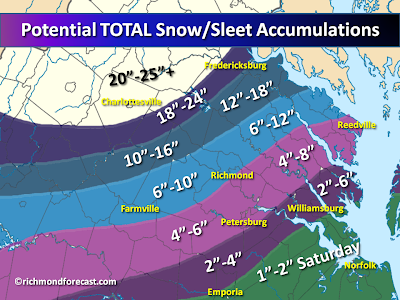
 The winter storm is now underway and snow/sleet will continue over much of the region into the early evening. This will be a multi-part storm for the Metro Richmond area and much of the surrounding region. That's because we'll have the accumulating snow and sleet, followed by a change to rain tonight and then back to snow early tomorrow morning, with more significant accumulation possible. So while my earlier map showed potential accumulation for the metro before the changeover, I thought I'd post this one to show the potential TOTALS of snow and sleet for the entire storm. Keep in mind that rain in many places tonight will pack down or even wash away some of the afternoon snow, so the totals will be skewed. This map represents the potential accumulations for today and tomorrow added together. Locations well north and west of Richmond, from Charlottesville to northern Virginia/DC/Baltimore will stay mostly snow with some sleet mixed in, and they will likely need a yardstick to measure 2 feet or more of snow!
Here's the lowdown for what to expect in your neighborhood:
Metro Richmond (city and east) down to southern Chesterfield and east to Urbanna
-- 2 to 4 inches of snow this afternoon
-- changing to rain this evening (some heavy rain possible overnight)
-- back to snow by morning, with 3-5 inches possible tomorrow
North and west of Richmond (from Short Pump/Hanover to the Northern Neck/south to Farmville)
-- 4 to 8 inches of snow possible through this evening
-- mix with and possible brief change to rain tonight
-- back to snow by morning, with 3-5 inches possible tomorrow
Farther north and west (from western Goochland/Hanover up to the upper Northern Neck
-- 8 to 12 inches of snow possible through later tonight
-- sleet and even some rain may mix in tonight, back to snow tomorrow morning
-- 3 to 6 inches of snow possible tomorrow (highest on the Northern Neck)
Fredericksburg southwest to Louisa and Buckingham
-- 8 to 12 inches of snow possible through later tonight
-- mainly snow and sleet overnight, all snow tomorrow
-- an additional 8-12 inches possible through tomorrow
Charlottesville up to northwest VA/DC/Baltimore
-- mostly snow (some sleet may mix in)...20-25 inches + likely
Well south and east of Richmond (Tri-Cities to Williamsburg)
-- 1-2 inches of snow/sleet possible
-- changing to rain this afternoon, some heavy rain possible tonight
-- 1-3 inches of snow possible tomorrow (2-4 inches for Williamsburg/Middle Peninsula)
Extreme southeastern Virginia/Hampton Roads (and Emporia)
-- 1-3 inches of rain
-- changing to snow tomorrow
-- 1-2 inches of snow possible tomorrow afternoon/evening


No comments:
Post a Comment